
WHAT IS A WATERSHED?
WHAT IS A WATERSHED?
The Scituate Reservoir Watershed is made up of the land that water flows across or under on its way to the Scituate Reservoir. How the land is used will directly impact the quality of the water. The more highly developed the land is – the more pollutants that are likely to enter the reservoir. But before the water makes its way to the reservoir, much of it passes through the groundwater that feeds the wells of residents living in the watershed. When residents work together to protect water resources, everyone benefits – from your own family drinking your tap water, to your next door neighbor, to most residents, restaurants and businesses across RI, as well as future generations.
Providence Water owns about 33% of the land surrounding the reservoir, and the vast majority of that land is managed forest land. Keeping land forested is the best way to protect drinking water at its source, as opposed to heavy treatment later in the distribution process. The remaining 67% of the land is owned by municipalities and residents living in Scituate, Glocester, Foster, Western Johnston and a small portion of Cranston and Smithfield, RI. Providence Water wishes to recognize and thank these landowners for employing good stewardship techniques on their land, as the entire state benefits – our water is ranked #2 in the nation!
The quality of drinking water in the Scituate Reservoir Watershed is directly related to land use within the watershed boundaries. This site is designed to help you understand the land water connection that exists in all watersheds as we deal specifically with the Scituate Reservoir Watershed.
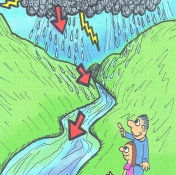
In order to understand this connection, it is important to understand what a watershed is and how it works. Watersheds are formed by land and hills. A watershed is the land that water flows across or under on its way to a stream, river, or lake. Within each watershed, all water runs to the lowest point – a stream, river, or lake. On its way, water travels over the surface and across farm fields, forest land, suburban lawns, and streets, or its seeps into the soil and travels as ground water. Everyone lives in a watershed, but not all watersheds supply drinking water. Click here to determine your watershed address.
See also: Conservation Farming
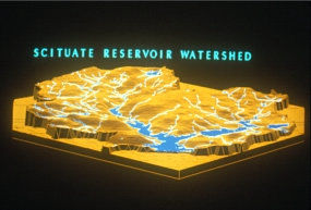
In the Scituate Reservoir Watershed, the streams, rivers, and ground water lead to the Scituate Reservoir which supplies drinking water to over 60% of the people in Rhode Island. Figure A (below) shows the elevation of land. As you see, the reservoir bodies of water are the lowest elevations in the watershed.
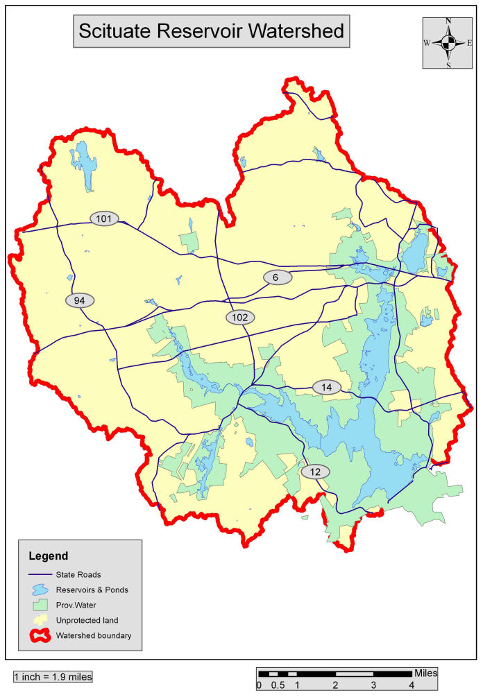
Figure B at right shows the actual geography of the land and the delineations of the watershed boundaries. Boundary lines
are red and represent highest elevations of the land. Upon leaving the Scituate Reservoir, water flows to the Pawtuxet River
and eventually into Narragansett Bay. The Scituate Reservoir Watershed is located primarily within the rural towns of Scituate,
Foster, Glocester, and also includes parts of western Cranston, Johnston and a small portion of Smithfield. The total drainage
area covers 93 square miles or nearly 60,000 acres. Within the larger watershed, the Providence Water property is made up
of surface reservoirs covering about 5,000 acres and another 15,000 acres of surrounding forestland. Providence Water owns
about one third of the land in the watershed and relies heavily on local municipalities and private landowners as stewardship partners.
The six reservoirs cover a surface area of 4,563 acres and have a combined capacity of 41.268 billion gallons. Over 12 thousand acres (about 19 sq mi) of managed forestland provide protection to a water resource renowned for high quality. Keeping the land forested is the best land use practice for water quality protection. Forested areas absorb water in the roots of trees while the leaves and needles slow the velocity of precipitation reducing soil erosion. This adsorption into the roots also increases the amount of water that can potentially accumulate as stored ground water. Roots of trees, shrubs and other vegetation hold soil in place, another factor in reducing soil erosion.
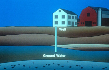
If you live in the Scituate Reservoir Watershed and have a well, you are drinking ground water. Ground water is the water under the ground (see illustration at left). The level of ground water is level with and connects to surface water. This level of water is called the water table and it changes throughout the year dependent on precipitation levels.
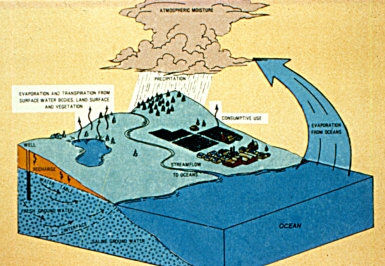
The soil beneath the water table is called the saturated zone because the soil particles are saturated with water and the soil above the water table is called the unsaturated zone. Ground water slowly flows toward and into surface water. Well water systems pump water from the ground directly to your faucet. The water levels in ground and surface water are directly related to the water or hydrologic cycle (see illustration at right). In times of drought the water table is lowered and water conservation is critical.
Water from the Scituate Reservoir is considered pristine, but help from watershed residents is needed to keep it that way! The watershed consists of both ground water, which feeds the wells that most residents drink, and surface water, which feeds into the Scituate Reservoir that over 60% of Rhode Islanders rely on. By being careful about what types of pollution end up on the ground, watershed residents will protect both the Reservoir and their own private drinking water wells.
Click here to read more information about how water from the Reservoir is distributed.
Built with Mobirise